Gozo, Malta

20180129_115148.jpg
Sanap Cliffs – boat for scale

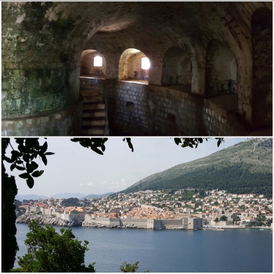
Researching Malta, most of the focus centered on the summer weather, the beaches, the bath-warm seas. But since we were visiting in January, these didn’t really apply. We’d seen a few items about walking trails, and that sounded good, but didn’t pay too much attention. At just 26 square miles, we weren’t sure how much the island could cram in. The answer truly surprised us. No matter which direction we walked from our home in Marsalforn, the views stunned. Every town and corner of the island had a distinct personality and landscape.

20180207_204932.jpg
Blustery arrival, Ggantija Temple

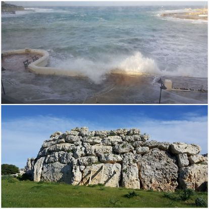
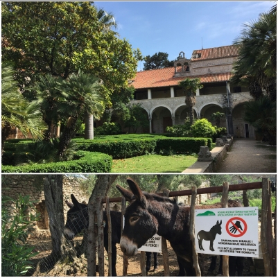
Inland to the southeast of us, the small town of Xaghra held a mysterious Neolithic temple and a more modern Parish Church which stunned us with its intricate interior. Following the coastal trail rather than the road, we passed small cliffs high above the green slopes. Below us the Mediterranean wrapped itself around the island’s shore. Ending up at Ramla Beach, the temperatures were almost nice enough for sun bathing.

20180207_205045.jpg
Xaghra Parish Church, near the salt pans

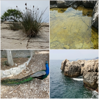
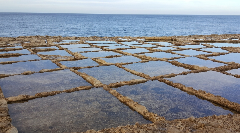
Walking west from our apartment led to another set of views entirely. Along the low rocky coast, salt pans are still active in hotter seasons. The shallow pools reflected sea and sky, a myriad of blues. Often people fished. The only downside was passing by the shooting range; the sharp pop of guns didn’t add anything to the day.

20180106_155216.jpg
Salt pans

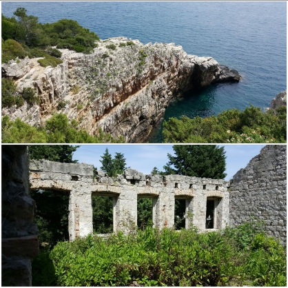
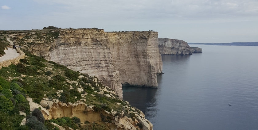
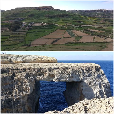
Soon the ground swelled upward. The shoreline grew steeper, finally reaching vertical around Wied Il-Mielah, a striking sea arch. The Azure Window, the more famous arch, crashed into the sea in 2017. Il-Mielah has seen an uptick in visitors but still feels underappreciated. A few climbers scaled the sides and a family took photos along the viewing ledge.  Continuing beyond this arch, the cliffs took over.

20180207_205211.jpg
Terraced hills and Wied Il-Mielah

The path, marked with red blazes, wandered though lunar-like landscapes of wind-smoothed stone. In other spots the ground was lush with flowers. And thistles, too. It was a ‘calm’ day my Maltese standards, the wind only picking up to 15 miles an hour or so, but coming over the top of the rock it gusted at random intervals.

20180207_205652-2.jpg
The landscape varies a lot for such a small island

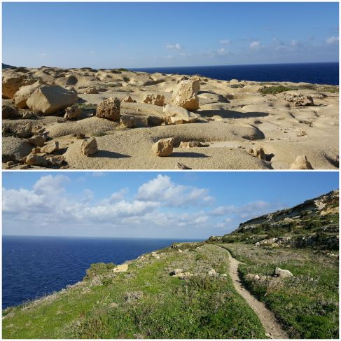
Rounding the northwest corner of the island, we lost the path for a bit. But with help from Google Maps we got back on track and soon the area around Dwejra was in sight. The island drops away into the blue, a wide horizon shows off the sunset. With no more Azure Window, there are fewer tourists. And most stayed near where the tour bus dropped them off. We preferred the areas a bit further out – from Wied Il-Mielah all the way to the end of the hike, we only saw three other people.

20180207_205527.jpg
Cliffs around Dwejra

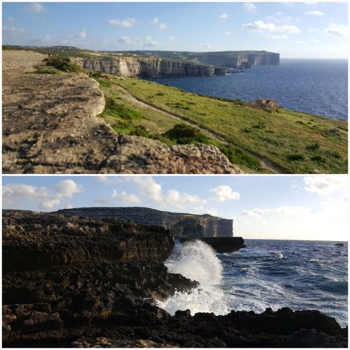
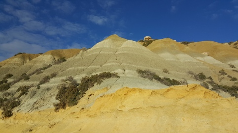
Starting another hike at Xlendi, we again hugged the tops of the cliffs. The Sanap and Ta’ Cenc cliffs are just as high as those near Dwejra, though they curve a bit less so there are fewer views photo opportunities.  As we neared Mgarr, where the Gozo Channel Line docks their ferries, the trail dipped to sea’s edge. We skirted under hills formed of layers of gray clay and near rocky beaches.

20180129_152127.jpg
Layered cliffs near Fort Chambray

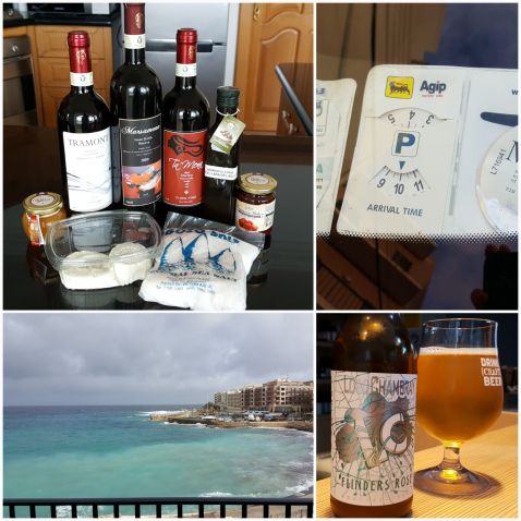
Coming back from a long hike, a tasty treat was an order. We visited Ta’ Mena Estate during our first week and brought home a hefty load of wines, local cheeses, salt, and konserva (a thick tomato paste blended with salt and sugar, great on toast). Their wines were especially tempting, relatively cheap but wonderfully rich. We went back several times to restock. Beer was thinner on the ground, but the island’s single brewery, Lord Chambray, works to reverse that trend. They craft several styles and were happy to give us a tour of their space as well. My favorite proved to be their Flinders Rose, a gose beer made with local sea salt and caper flowers.

20180207_205403.jpg
Local eats & drinks, timed parking, wind-churned waters

Kevin made a traditional rabbit stew with fresh meat, letting it simmer on the stovetop for hours. It lasted for several days and only got better with time. If we passed through Victoria, the island’s capital, we stopped for pastizzi (a flaky pastry stuffed with cheese or peas) or qassatat (a larger, doughier cheese or spinach pastry). Both cost just a few cents and filled us up quickly.

Between long walks, beautiful scenery, tasty local dishes, and the ever-present Mediterranean, Gozo might be my favorite spot to spend a winter. With just a handful of other tourists and a relaxed pace of life, we felt like we could explore the island on our own schedule.


Jurmala & Sigulda, Latvia

In a surprise twist, just thirty minutes outside Riga are the wide, sandy beaches of Jūrmala. I never thought to associate Latvia with sun and sand. But the locals certainly do. On a hot summer Friday, it seemed half of the country was along the Jūrmala coast. The Baltic water wasn’t warm enough to tempt me to swim (though others were indulging happily), but it was the perfect spot for relaxing. There are small restaurants and ice cream stands along the shore and areas of “active” and “passive” recreation. Zones for sunbathing and being lazy! This beach has it figured out.

20170818_134635
Around Jūrmala

A little further inland is the heart of the tourist area, with pedestrian streets full of small shops and restaurants. We spotted an Orthodox church under construction and Latvia’s largest bronze globe (oddly specific, but it’s something). In one of the main parks was a viewing tower that was free to climb. The catch was that the floors were all grated metal, so looking down was a bit vertigo-inducing. From the top level we saw Riga, tiny in the distance, and the Baltic Sea on the nearer horizon. Since most local buildings are low, the surrounding forest appears nearly uninterrupted.

20170818_142816
Viewing tower in Dzintaru mežaparks

In the opposite direction from Riga is Sigulda, a small town at the start of Gaujas National Park. It is where they happen to keep the castles. In Sigulda itself are the remains of the Castle of the Livonian Order. The oldest castle dates from the early 1200s, though it underwent many iterations through the centuries. Parts of the towers and wooden battlements have been reconstructed and were open for exploration.

20170818_143028
Livonian Castle in Sigulda, path to Turaida

From Sigulda, it was only a little bit of a hike across the river and through the woods to get to the next castle, Turaida. Along the way was the largest cave in the Baltic States, Gūtman’s Cave. The cave was really more of a giant niche with a small spring inside, but the walls are covered in graffiti, some dating back centuries. Clearly, it was a big deal to have your name on the wall, and some people even carved scrolls or family crests to make their marks more visible.

20170818_143315
Gūtman’s Cave – the largest (by volume) in the Baltics

Hiking a little further, up and down the local hills (they kept being referred to as mountains on local signs), we arrived at Turaida. This castle is inside a museum/reserve with preserved buildings and a sculpture park. But the main attraction is the castle. Again, it was built in the early 1200s and has been reconstructed. A tower and some recreated battlements loomed over lower ruins.

20170818_143511
Turaida Castle without and within

Perhaps the best part of the museum was a giant swing. Sized so that two adults could stand on it, maybe it’s a forerunner of kiiking?

Overall we hiked about 12 kilometers around the towns, though we didn’t make it to the third castle, Krimulda, because we needed to catch our train back to Riga. The area around Sigulda was beautiful and there are plenty of other trails to explore if we ever make it back.

Thirty Things I Learned Travelling Before Turning Thirty

For my 30th birthday, I thought it might be fun to look back at the last 365 days and what I’ve learned. It is incredible to realize that we’ve been on the road for more than 15 months, and just how much more there is to see!

1. I hate the way airlines board planes and love flying. Just like I hate check-in at airports but love waiting for the flight and wandering the concourse.

2. Morcilla – blood sausage common in South America – is delicious as long as you eat it hot before the texture gets more unbearable as it cools.

3. Chilean volcanos love to play hide-and-seek. They are massive but still vanish almost with it a trace into the clouds.

4. The library at Trinity College really looks like the pictures, no color enhancement needed.

20160626_120445
Trinity College Library in all its non-color-enhanced glory.

5. Finns on the ferry from Estonia all look like alcoholics. In their defense, they need to buy in bulk and take it with them when visiting their neighboring country… it’s a bargain compared to local prices.

6. Some brands are obnoxiously global like Coke and Colgate and shampoos. Dish soap, though, has a much higher localization rate.

7. Croatian and most Latin American beers are not to my taste. Too light, too beery. Poland, though, is so far the king of beer countries.

8. I am not impressed by beach resorts in Cancun. They are all carbon copies and a weird bubble unto themselves.

9. Antacids in South America are pricey. I guess the food is bland enough (at least on the eastern coast) that heartburn isn’t a problem.

10. I LOVE food-stuffed bread. Polish pierogies, empanadas, Estonian pastries, Hungarian langosh. GIVE ME ALL THE CARBS.

20170416_224626
Carbs = life.

11. Budapest is gorgeous. No wonder so many people told us we’d love it.

12. Eurovision should be a holiday in Europe. I will now base travel decisions around this show and feel no shame.

13. Sweet fruit wines from the Baltic regions deserve more credit. At least they have the common sense to know grapes won’t work there.

14. Torres del Paine is one of the most beautiful places I’ve ever seen. Destroyed my legs for days and was worth all the pain and hours on buses to get to hike each day.

20170415_231100
Here are some photographs not doing justice to Torres del Paine.

15. Photographs do nothing justice (almost – see #4 for the exception proving the rule).

16. Both Anna Karenina and Middlemarch look intimidating but are brilliant reads.

20160830_181054

17. In Peru, everyone asks if you’ve gone to Macchu Pichu and looks at you like you are crazy if you say no. Ditto Iguazu Falls in Argentina.

18. The hardest part about travelling is the unpredictable selection of books. No, I’m not going to get an e-reader.

19. Purse snatching can happen anywhere. Having a sturdy purse might keep the strap from breaking and sometimes helps you keep your stuff. But that can be good or bad… depending on how much the robber has invested into getting your stuff away from you… I really can’t recommend what is better.

20. For every place we visit, at least 3 get added to the list.

21. Romania is way more interesting than I had realized before going there. I hope we can get back to see Cluj-Napoca and Timișoara.

22. Just about every country has money that is more colorful and pretty than US currency. Uruguay’s coins have animals. Chile’s is a rainbow of colors and makes you feel rich (that 650:1 exchange rate). Romania’s bills are plastic so you can even toss them into fountains for luck.

23. Szellemirtók is a great movie. Don’t be a hater.

20170415_230947
It’s a good movie. There was tasty popcorn.

24. Krakow, Poland and Montevideo, Uruguay are my two favorite cities for street art and murals.

25. I’m never too old to climb around fortresses and tunnels.

26. I might be at least partly Estonian?

20170415_230858
I ❤ Estonia.

27. High heat and humidity is a terrible combination, ergo I could not live full time on the Yucatan Peninsula. Likewise, year-round chilly days and especially windy winters are not to my liking. Sorry Punta Arenas, I won’t be moving to the far south of Patagonia permanently.

28. Travelling and living full time in some small spaces with another human, even one I’m as madly in love with as my hubby, can occasionally be trying. Especially when mosquitoes are fierce, the kitchen is under-supplied, not all the appliances function, and the sink drains don’t have a u-bend to keep smells in the sewer and out of the house. And it is absolutely worth every second.

29. Inca and the related civilizations of Peru have the best pottery.  THE BEST.

20170416_224909
Surprise garbage can guy is my favorite. I relate.

30. Sometimes the mystery wine bottle is full of tasty alcohol. Sometimes it is terrible awfulness that gets dumped right down the drain. The only way to know is to try it.


Torres del Paine – Los Cuernos

Waking up the day after the Torres Mirador hike was a new lesson in leg soreness. Our rental apartment’s bedroom was on the second floor, and I made sure I only had to go down the stairs once. I don’t even want to think about the multiple minutes it took to get to the first floor. My knees seemed as though they were discovering  their ability to bend for the first time. Clearly, they were not excited by that prospect.

Once again, we made sure we had our our layers, snacks, and the makings of lunch sandwiches, and were out the door before 7 a.m. The bus ride was gorgeous again, watching the sun rise over nearby mountains, the driver honking to shoo herds of guanacos off the roadway. At Laguna Amarga, we showed our stamped tickets from the day before and headed back to the bus. This time we were headed to the last stop at Pudeto, about another half an hour beyond the entrance. After a short wait, we were joined by many of the other passengers, most of whom were heading to the ferry and longer hikes.

20170324_154601.jpg
The most majestic guanaco  – presumably king of all he sees

Our bus arrived at Pudeto just after 10, and we breakfasted at one of the picnic tables behind the cafeteria. Once again, the sun was warm and we had over-layered in anticipation of bad weather. A couple we had seen the previous day joined us as we were finishing and were impressed we had done the entire Torres hike in a day with two bus rides thrown in. They were smart enough to have at least one knee brace, however. We settled for ibuprofen.

The Cuernos Mirador trailhead begins a few hundred feet up the road from Pudeto, which is thankfully a smooth slope. We picked this trail to do after the Torres Mirador because it was much shorter and much flatter. We also wouldn’t have to rush to make it back for the 6:30 bus pickup so we’d be able to spend more time enjoying the vistas.

20170324_115805.jpg
Wind warning, the Salto Grande, and the Condor and Cuernos peaks

This trail begins as a flat walk to the Salto Grande waterfall. The falls crash into a small, dark-walled canyon with smaller torrents above and below. Like many places around Torres del Paine, the canyon walls reveal a small section of the rock layers that help form the park’s geology. These layers are made up of stone of various hardnesses, so they often wear unevenly. In some spots, this means that fins of rock arc up from their surroundings and create formation that almost look like manmade fences. Just beyond the waterfall is a viewpoint of the Condor and Cuernos mountains where many day-tours stop.

But the trail continues and so did we. By now, our legs had warmed up to the idea of some more walking and hurt less. The next section of the path took us gently around and through areas of forest that had been burned over in human-started forest fires. While many of the trees in this area are still standing, their bare branches eerily reach toward the sky as if in supplication. This area perfectly illustrates the reason the park is so strict about camp fires and stoves – the wind can pick up in seconds and the flames can be out of control in moments. As far as I know, all the recent fires have been caused by tourists. Fines have been increased and enforcement is strict.

20170317_152350.jpg
The Condor and burned-over forest

Down past a lake and up over the final ridge, and we were at the Mirador. There were a handful of people snacking on the rocks, but this trail sees much less use than the Torres does. We settled in and ate our lunch, chatted, took pictures, soaked in the views. Echoing across the lake, occasional glacial crashes could be heard. We saw one small section collapse and side down a rock face – what must have been hundreds of feet but looked small across the distance.

Patience paid off and eventually we were the only ones at the look out. Without other voices and low wind, we could hear the ice and rocks grinding almost continuously. We could watch wind push sparkly waves across the lake at our feet. It was absolutely enchanting. Every direction you can look from this point is beautiful.

20170317_122022.jpg
The Condor stretching its snowy wings across the mountain peaks

Again, the wind picked up suddenly in the afternoon, this time about 3 p.m. Signs at the beginning of the trail warn that gusts can reach dangerous levels quickly and so we donned our jackets and started back. As we walked, the breeze only got stronger, confirming our decision. By the time we reached the waterfall viewpoints, there were moments where it was difficult for me to walk when the gusts swept in just right. Not quite Iceland bad, since we could still breathe facing into the wind, but gaining strength. The spray from the falls was now reaching up and over the viewpoint and it seemed wisest to head back to the cafeteria.

20170317_143701.jpg
The Cuernos (Horns)

We spent the last couple of hours before our bus arrived sipping beer and warm coffee in the cozy cafeteria building and watching clouds being pushed over the distant mountains. After an hour or so, the ferry arrived and we were joined by dozens of others.

While we didn’t get to see the iconic glaciers or trek the ‘W’ or ‘O,’ we at least got a decent taste of Torres del Paine. It really is one of the most spectacular places in the world. The two days partially filled our hiking meter, but left us craving hikes in the Pacific Northwest. We’ll have a lot of trail miles to make up for when we return, though I am so happy to have seen and hiked in one of Chile’s most iconic landscapes.

20170317_164053.jpg
View from the Pudeto cafeteria

In case anyone wants to day hike from Puerto Natales, there are several bus companies that make daily trips to Torres del Paine. We used Bus Sur because they let us buy tickets in advance online (though if you buy in person at the terminal, you can get a discount on round-trip tickets). Other companies like Juan Ojeda, Maria Jose, and Bus Gomez also make the trip. As a general rule, buses leave Rodoviario Terminal in Puerto Natales between 7 and 8 a.m. in the morning and arrive at various points in the park between 9 and 11. For day hikers, the returning evening buses leave between 6:30 and 7:45 p.m. and arrive in Puerto Natales between 9 and 10 at night. It makes for a very long day, but there are several hikes that can be done in that time.

If we opted to do the Torres hike again, I’d go on the same 7 a.m. Bus Sur trip since it is the first one to arrive and that saves time waiting in line during the registration process. But I’d consider taking a later return on a different line in order to have more time at the Mirador. After all, it is a shame to hike all that way and turn right around again. And that also gives more time for the shuttle to show up and get back to Laguna Amarga.

(Also if you happen to be at Rodoviario Terminal and the small bakery/minimart across the street is open – get their torte de calafate. The berries on top look like blueberries but are more seedy and bitter. It is an absolutely delicious dessert!)


Torres del Paine – Las Torres Mirador

Our stay to Punta Arenas was not going to be complete without a trip to Torres del Paine National Park. While it is possible to take a day-tour from PA, we didn’t just want to spend most of the day on a bus and only a couple hours in the park. We opted instead to find a cheap Airbnb and head to Puerto Natales for a couple of days. Due to a hassle getting a computer shipped to and from the US for repairs, we had to delay seeing the park until the very end of our time in Patagonia. But somehow we lucked out – ending up with the apartment we had been eyeing after another guest canceled and great weather for our hikes.

20170324_120015.jpg

Puerto Natales is about three hours by bus from Punta Arenas – and the entire drive is scenic. We passed thousands of grazing sheep, guanacos, and rheas, and saw wild flamingos for the first time. After arriving, we took in the town’s waterfront, which provided tempting views of the mountains we’d be visiting. A short stop at Unimarc set us up with groceries and snacks for the hike. We tried and failed to get to bed early even though we knew we’d need to be up by 6 a.m. for the two-hour bus ride to Torres del Paine itself.

20170324_115358.jpg
Thankfully reachable by bus – the Laguna Amarga entrance station

At the Laguna Amarga entrance, everyone got off the bus to register, pay the entry fee, and watch a safety video (NO fires, stay on trail, pack out all garbage). We also needed to get our tickets stamped so we could use them to reenter the following day. From there we hopped into a van acting as a hotel and campground shuttle. The gravel roads in the park are in fairly good condition, but the vans and buses still take the corners frightfully fast, especially when you are stuffed in with everyone’s camping gear and the pile is threatening to tip over with every turn.

After the short ride, we were left off in front of a cafeteria about a 10-minute walk from the Hotel Las Torres, where the Torres Mirador trail begins. Even walking up the last portion of the road, the view is stunning. It is hard to take a bad photograph; it is also hard to capture the vastness of the landscape.

20170316_100732.jpg

The trail begins innocently, taking hikers through some flat ground where giant hares keep the grass trimmed and where we saw a fox slinking around the bushes. After crossing the stream for the first time, the path starts gently upward. The first portion has a lot of small gravel and larger stones that are easier to walk up than side down. Many people had hiking poles, and that would have been a good idea, especially later in the day after our muscles started to burn. We also quickly realized that much of the path between the Hotel and the El Chileno refugio, about halfway up, is shared with horses. They are used to transport supplies and tired hikers up and down the trail, but also tend to use the path as a bathroom… Our limited packing space means I did the trail in cloth running shoes, so it was extra important for me to pay attention to where I stepped.

20170324_115506.jpg
Trail running along the river, a crested caracara at El Chileno refugio, one of many bridges

Despite it being fall, the weather was warm and we found ourselves shedding layers fairly quickly. Fortunately, we climbed into some trees and had shade to protect us from the sun. In Patagonia, the sun is always strong, even in a cool wind. We were glad for sunscreen and bugspray, since the nice day brought out the last of the mosquitoes as well. The first few miles of trail gain elevation and then lose it as the trail approaches El Chileno. Views of the surrounding peaks only confirm that every step downward means one more upward later. As we dropped beside the river, the forest surrounded the path. Moss-covered trees reminded up of the Pacific Northwest and this stretch was one of our favorites parts of the hike.

20170324_115601.jpg
Looking up the boulder field, the forest

Going up through the trees, we eventually came out along the boulder field that makes up the last kilometer of the climb. The sign warns it takes about 45 minutes to make it to the top – we took 40 and moved at a fast pace to fit our bus schedule. Here, sections of the trail are essentially stream bed – we climbed over wet rocks slippery with dust and mud. This single kilometer packs in about a thousand feet of upward gain. It is possibly the steepest section of trail we’ve ever gone up. It was especially crowded with people, and in some spots there isn’t much room, so stopping and pausing while others passed by headed the other direction was common.

And then, finally, after more than three and a half hours of hiking, the Torres themselves. They are spectacular, made more so by the turquoise-sunset blue waters at their base. Even with dozens of other groups eating lunches, it doesn’t feel crowded. The granite towers rise almost vertically out of the surrounding rocks – other nearby mountains are being worn down and might someday reveal other spires. The scenery leaves no doubt why this is one of the world’s best known hikes and one of Chile’s top destinations. Superlatives don’t cover it, and pictures don’t come close to doing it justice.

20170316_134432.jpg
Las Torres

Of course, only having nine hours from the time the bus dropped us off to when we expected to be picked up again meant that we only had about 15 minutes at the top. Our timing was fortuitous, however. After we’d been up there about 10 minutes, the wind started out of nowhere. I went from not needing a jacket to layering back up instantly. Clouds that had hung over distant peaks began to cover the sun. Standing up again after a quick granola bar, our legs were already tired and we still had almost 6 miles left to go. (No wonder you can order horses to take you back from El Chileno!).

Having not done much mountain hiking in the last year and half, we were out of practice. Scrambling down the boulder field, I shamelessly used by hands to steady myself and lower myself over taller rocks (my legs are not really that long). Once we got into the woods, it was easier and the trail mostly clear of rocks and roots. Going down and back up out of the river basin was the final straw for my knees, though. The last downward portion of the trail that takes you from forest back to the more open scrubland was slow and painful. So what I looked a little penguiny for the last rocky kilometer or so, I finished the hike and reminded myself that others who were in better shape are some of the best hikers in the world.

20170316_172125.jpg
Hotel Las Torres

We were faster than our 8-hour limit and had time for a beer from the kiosk at the trailhead before walking the last (mercifully flat) stretch to meet the shuttle. The bus back to Laguna Amarga was supposed to arrive just after 6 p.m., giving us about an hour before the 7 p.m. bus back to Puerto Natales.

That time came and went, as did 6:30 and 6:45. I started to get a bit panicky – as did several others who were waiting. The shuttle was called for a couple of times and finally arrived just before 7. Fortunately for us, most of the passengers were also supposed to be on our bus back to PN, so it was held for us at the Laguna Amarga entrance. It ended up leaving more than half an hour late. If we’d have known, we could have had a lot longer at the top or taken it easier coming down. Still, was thankful to have made the bus and not have to worry about getting seats on a later departure.

Back in Puerto Natales, we had just a few minutes to spare before Unimarc closed for the evening. We came away with a meal of as many empanadas as we could eat. The short walk back to our house made us grateful for the wine that was waiting. I’ve never had my tendons and muscles seize up so fast after a hike. I hadn’t looked at the mileage or the elevation gain beforehand, and we now discovered we’d gone nearly 12 miles with 3,000 feet of elevation gain (and then loss). I’d guessed it was more like 8 or 10 miles and 2,000 feet. At least I’d earned all the aches. Of course, we’d be up early the next day to do another hike – but at least we’d planned for a shorter one to follow our first-day adventure.


Isla Magdalena

If you are going to spend time in Punta Arenas, penguins are usually high on the to-do list. There are a couple colonies nearby, but the best known is the Magellanic penguin colony on Isla Magdalena. We purchased tickets through the Comapa agency downtown; the other option was to buy them at the terminal. We had skipped the overpriced penguin tours on the cruise, and this was our chance to make up for it.

The Melinka ferry leaves from the Tres Puentes terminal in the afternoons about 4 and arrives on the island about 6 pm. Buses or collectivos running directly to the terminal are rare, but just about all of them go to the nearby Zona Franca. From the duty free area, the terminal is just a fifteen minute walk away.

We waited in the terminal building for a few minutes until boarding. It was small but had spots to sit and decent pastries. Clearly, visiting penguins was a popular choice. Once on the Melinka, there was a warm cabin with seats across two levels. The space was a little cramped but there was another coffee stand and some videos showing off the gorgeous landscapes of Patagonia. I’d recommend bringing a book to pass the time sailing down the coast. (Four hours on a boat can be entertaining… or less so.)

Before arriving at Isla Magdalena instructions for behavior on the island are repeated four or five times in Spanish and English. They really want you to remember not to feed or touch the penguins or lay down on the path. But then we landed, the front of the ship was lowered, and the crowd was off.

We visited in late February, when summer starts waning and the penguins molt. The chicks were already grown so we missed our chance to see youngsters. But there was no getting around it: the island was full of penguins. It doesn’t have much else to recommend it since all the grasses and vegetation have been plucked to line penguin burrows, leaving only bare windswept rock.

It surprised me to learn that Magellanic penguins live in burrows while on land. They never struck me as digging animals, but apparently they do a pretty good job of it. At the other extreme, they also spend months also the also time in the ocean, swimming as far away as Brazil in search of meals.

The one of the left is so embarrassed to be molting!

The roped-off trail looped left, uphill toward the lighthouse, and then back towards the boat. Groups are only allowed to be on Isla Magdalena for an hour, and the length of the walk is timed to this. We took a few minutes to explore displays inside the lighthouse, but spent most of our time watching the penguins toodle awkwardly around on land.

We had relatively nice weather, but it is always windy and often rainy on the strait. Layers went a long way to keeping us comfortable while we were there.

Our ferry ride back seemed to pass more quickly, partly because dolphins were playing alongside the ship for a while. Getting back to the terminal at night makes flagging down collectivos more difficult and the buses had already stopped running. We waited a while but decided to take a metered taxi instead. The rate was many times higher than a collectivo would have been, but still less than $8 back to the far corner of town.

Overall, Isla Magdalena was definitely worth the trip and the price. Seeing penguins in their natural habitat and completely unafraid and unworried by gawking humans is an experience I’d recommend to anyone. All the penguin movies don’t do the real thing justice.

Stanley, Falkland Islands

Our most anticipated stop on the cruise was Stanley in the Falkland Islands. The day was a windy gray, but that was expected given the location in the middle of the south Atlantic. Our ship was too large to dock at the small pier or even make it through the narrow passage to anchor in the interior Stanley Harbor. Instead, we floated a thirty minute tender boat ride away in Blanco Bay.

Our goal for the day was to hike to Gypsy Cove (and avoid the $20 per person shuttle fee and the many-times-more-expensive tours to the large colonies of penguins). The cove, and its small Magellanic penguin colony, is about 4 miles from the pier in Stanley. We asked at the information desk in front of the pier, and the woman behind the counter seemed a little skeptical of our intentions, but nonetheless provided us with a map and verified that a shore path covered much of the distance and the rest was on sidewalks or on gravel roads.

wp-1485633852130.jpg
Arriving amid splashes on the tender boat and an old waterfront pier

I searched the internet beforehand and wasn’t able to find directions, so I thought I’d summarize the path. Basically once you land at the main jetty, turn east (left as you walk on shore) and head down Crozier Place and along the shorefront on Ross Road East. Where the road begins to curve away from the water, a faint set of tire tracks continues. This is what you follow. It eventually turns from a vehicle path into just a walking track and follows the (slightly muddy) shore all the way to the single-lane bridge. Here we followed the road for a few minutes and then cut back to the shore on a path that headed down toward the wreck of the Lady Elizabeth. The trail follows the bay’s curve and then crosses over the top of a rock-topped hill where it rejoins the road for the final stretch to Gypsy Cove. The walk there took us about an hour and a half, though we had the wind behind us and good weather.

A lot of places around the world claim that their weather changes quickly, but in the Falklands the conditions really vary with astonishing speed. We arrived with light rain and a slight wind that got faster and colder throughout the hike. At Gypsy Cove it started to rain in large splashes. We got a lift back into Stanley as some people from the boat who had rented a vehicle took pity on us. That turned out to be good luck as the rain got heavier and continued for the next couple of hours. We had enough layers, rain coats, and an umbrella that would have gotten up back on our own, but it would have been a wet and chilly ninety minutes.

wp-1485633993764.jpg
On the way to Gypsy Cove – boats now bad at floating and a King penguin

We were lucky enough to spot other kinds of birds on our way to see the Magellanic penguins. I’m not a birder by any means, but based on signs and some fast internet searching, we passed a couple of night herons looking for lunch in the shallows, large turkey vultures, and a molting King penguin. The King had chosen a quietish beach on which to get his new set of feathers – we kept a decent distance for taking a few photos. Later we learned if they are annoyed by crowds they will try to go back in the water but will often die due to exposure. They also don’t eat as they molt and regrow feathers; they gain quite a bit of weight in advance and go into a semi-hibernation and if they are fed their body will go into organ failure.

There are several boats along the path that are sunken or beached and being slowly abraded by the elements. The largest and most-photographed is the Lady Elizabeth, which was stranded in Stanley decades ago after being declared unseaworthy and is now rusting in Whalebone Cove. Yorke Bay, also passed on the way, is full of hummocky sand dunes and mines places there by Argentinian soldiers during the Falklands War. The area is still off limits and has become something of a safe zone for animals.

wp-1485634117521.jpg
Rocky landscape, turkey vultures (I think), still-mined Yorke Bay

Gypsy Cove did provide penguins, though here you cannot get as close to them as you can at the large colonies in other parts of the islands. Still, we saw several Magellanic penguins right away, coming back ashore after hunting. With some patience, we saw at least a dozen others, including some that were on the slopes of the hill and much closer to the viewing areas. On land they seem out of place, like toddlers learning to navigate stairs for the first time, but the water was clear enough that we could also seem them swimming with graceful turns that confirm they are more at home in the water.

wp-1485634208754.jpg
Magellanic penguins in the water and on land (and one photobombing gull), local plant life

Back in the city (Stanley is technically a city even though it has just over 2,000 inhabitants), we saw the British war memorial, Christ Church Cathedral, the West Store Supermarket, and inside of the Globe Tavern. The Tavern was dry and had beer, and it was hard to argue with prices that weren’t that inflated despite the Islands’ lonely location. The store and bar even kindly take US dollars.

Stanley is quiet and very picturesque. It looks much like any other small town you might find in the US or England, through just about every driveway houses a Range Rover with bumpers covered in British and Falkland Islands flags. Many people also keep horses for riding and racing. I imagine it would be a very peaceful place to live, though any small town comes with pros and cons.

wp-1485634298793.jpg
British memorial to the Falkland War, Anglican Cathedral, inside the Globe Tavern

I want to say at little more about the West Store – it is one of the best-provisioned I’ve been inside in a long time, especially for its size. There were Poptarts (multiple flavors)! Doritos! Chocolate bars! Nutella! Thai noodle mixes! Hot sauces! Donuts! A decent selection of Margaret Atwood books! Of course, it serves as THE STORE for the islands, so it also has all the staples a grocery and drug store need. Based on its contents, I could eat quite happily in the Islands even though the weather might get wearing after a while.

Peleș and Bran

We took a few days last week to escape Bucharest and drive to the countryside. Our goal was a cabin just outside of Bran (of Transylvania/Dracula tourist fame). The cabin was a peaceful experience – we overlooked a small hayfield and mountains were in the distance – but getting there was not. Kevin always draws the short straw when it comes to rental car driving and I attempt navigation. I knew where we were going, though trying to determine how to get through some of Bucharest’s intersections defies all logical road rules. Sometimes turning left on green requires first going into the right lane and waiting for a second light to change. Drivers here also tend to stop by the side of the road with no warning and for any reason. It’s all very unpredictable.

wp-1466536703945.jpg
Local wildlife, old fashioned haystacks, our cabin once the grass was mowed.

On the highway to Bran we stopped for a few hours to tour Peleș Castle, the summer residence of the royal family from the late 1800s. King Carol I made a brilliant choice. Peleș is in the mountains where summer is cooler and hiking and hunting were abundant. The castle feels very Bavarian (Carol I was actually German), and looks like a cabin on steroids.

wp-1466601544552.jpg
Peles Castle on the walk up and the castle courtyard.

The palace interior is anything but cabiny – Venetian glass, marble, carved walnut, all the amenities the turn of the century could provide. I think it is the first castle we’ve been where electricity and telegraph lines were installed as it was built. And when an interior courtyard was covered over to make a grand staircase and reception hall, the King and Queen had the foresight to put on a retractable roof. Clearly, someone in the family was loaded.

wp-1466536669731.jpg
The castle’s weapons collection, stained glass on the retractable roof, and oversized doors.

The tour at Peles lasted about 45 minutes, and then we were back on our way. We arrived at our cabin mid-afternoon, just as a thunderstorm was rolling over the top of the mountains behind us. Thinking Bran Castle would be at its eeriest with rain and lighting as a backdrop, we found an umbrella and walked into town. Contrary to what many photos had us believe, Bran Castle isn’t situated alone in the mountains – there is a small town at its base that serves tourists and is full of souvenir shops and restaurants. Despite this, the castle sits separated in a park of its own and manages to look at least a little ominous.

wp-1466536689097.jpg
Not-so-frightening castle door, tower!, and the secret staircase (because all quasi-haunted buildings need one).

Of course, it used to be homier than it is now (the interiors currently are almost completely white and very stark). Queen Marie used this castle as her own summer retreat and a few swatches show it would have been painted with floral motifs and been much cozier.

Two rooms were dedicated to the Dracula legend and all the movies that have come out of the Bram Stoker’s book. Bran Castle does seem to be an inspiration for the story, but Vlad didn’t live there. It just conveniently looked like the castle described in the book and was suitably close to Bucharest.

wp-1466536743632.jpg
Castle Bran’s courtyard, looking toward surrounding valleys from a hike above Bran.

Castles aside, the Romanian countryside is gorgeous. The plains felt Midwestern. Corn and wheat were growing in abundance. We passed shepherds with small flocks of sheep and cattle every few miles. Horse drawn carts were still in use in the smaller towns. Up in the mountains, many roadside stands were offering berries, and livestock grazed next to the road, watched by their handlers. Traditional hay meadows, still scythed by hand, dot the tops of smaller mountains. Haystacks are also made by hand and are scattered throughout the small fields. Our neighbors were making one the morning we left – a tall pole through the middle and a tripod of legs make the base for the stack.

wp-1466536716487.jpg
Horse & cart patiently waiting for their owner, hay drying on the lower barn roof, an Orthodox church.

Driving back into Bucharest was less stressful than getting out of the city. We returned on a Friday, and there was a steady stream of nice cars going the opposite way. Something to do with a holiday weekend and the 90+ degree temperatures we returned to. In any case, we were happy we had the chance to escape mid-week and I’d definitely love to return to the Carpathian Mountains in autumn.

Lokrum Island

Lokrum Island is only 10 minutes by ferry from Dubrovnik’s Old Harbor but manages to completely leave the city behind. The noon sailing was packed and we sat on the boat’s edge looking down over the water.

wp-1463213672367.jpg
Sea cliffs and abandoned parts of the fort.

Lokrum is protected as a forest reserve and holds a few ruins – it was once home to a monastery and a fort was built on the highest point in the 1800s. Now, however, legends declare the island is haunted and no one is allowed to spend the night.

wp-1463213664208.jpg
Around Lokrum – lots of shore plants and tidepools.

The main attraction is wandering around the island itself. That, or paying too much for food and drinks at one of the cafes. We spent our four hours exploring trails and crumbling buildings. The highlight turned out to checking out tide pools where jagged sections of limestone vanish into the sea. The cracks in the rock wear down much faster than the surrounding stone and make interesting (and photogenic) pools and channels for sea creatures to hide in. Fish and small crabs were the most lively occupants. I was hoping for starfish, but didn’t manage to find any.

wp-1463213668388.jpg
Fort Royal’s interior, Dubrovnik through the trees.

Much of the monastery was off-limits for restoration, but a small museum in its wings remained open. It houses a replica of the Iron Throne. We took all the requisite pictures of ourselves seated in it trying to look kingly and evil.

Fort Royal, built by Napoleon’s troops, is now surrounded by trees blocking some of the view. Still, from the top of the tower we could see most Dubrovnik’s walls and miles of mountains sloping down to the Croatian coast.

wp-1463215051704.jpg
A pointy chair fictional people are always fighting over, cave along the shoreline, bunnies & fire hoses.

The most crowded spots were the cafes near the port and the fortress. Walking a few minutes down any forest trail let us escape from other tourists. The quiet of the island was a welcome relief after the cramped feeling of the Old Town, even though we could hear jet skis and some especially loud motorcycles on the mainland highway. Parts of the island were full of pine trees, and it almost felt like hiking in eastern Washington and smelled a little like Christmas.

wp-1463215055760.jpg
Cloister interior, island donkeys.

Unlike the mainland, there seem to be no cats on the island, but bunnies and peacocks were released at some point and have taken over the lawns by the restaurants. While the rabbits are cute, the peacocks scream too loudly and too much. Fortunately, they do not like the brushy parts of the island and it’s easy to avoid them. Fire hoses were also strangely common. Fire danger on the island was very high (despite rain in the forecast) and there is no underground water system, so this is the best way to respond quickly to any flames.